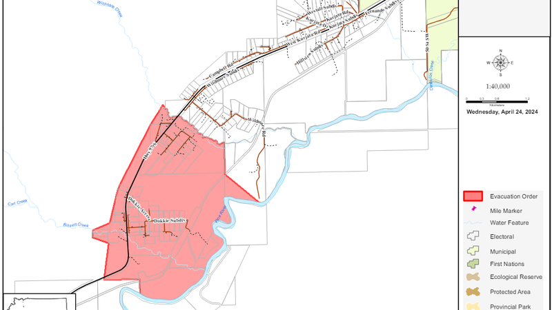
Map courtesy: PRRD
Transportation

Wildfire causes Highway closure just south of Chetwynd

Apr 24, 2024 | 4:42 PM

CHETWYND —Update: Highway 97 just south of Chetwynd has reopened to single-lane alternating traffic.

In addition to that, the evacuation order for the area has been lifted and an alert has been issued instead.

Earlier: The Peace River Regional District (PRRD) has issued an evacuation order for the Wildmare Creek near Chetwynd.

The following areas are affected:

Directly West of Bisset Creek
South to Pine River
East to Wildmare Creek

YOU MUST LEAVE THE AREA IMMEDIATELY
Members of the local police department and other agencies will be expediting this action. A person must not enter the area identified above and in the attached map for purposes of residing, occupying or visiting the area.

WHAT YOU SHOULD DO

  • Follow the travel route Highway 97 North and register at: 5400 Hospital Rd, Chetwynd – District of Chetwynd Municipal Office
  • If you need transportation assistance from the area, advise the person providing this notice or call 1-800-670-773.
  • Do not turn off your natural gas. FortisBC will turn off natural gas service as needed.
  • Close all windows and doors.
  • Close gates (latch) but do not lock.
  • Gather your family and, if you have room, take a neighbor or someone needing transportation. Do not use more vehicles than you have to.
  • Take critical items (medicine, purse, wallet, and keys) only if they are immediately available. Take pets in pet kennels or on leash.
  • Do not use the telephone unless you need emergency service.

An evacuation alert has also been issued due to the Wildmare Creek fire.

Based on recommendations from BC Wildfire, the Peace River Regional District has issued an Evacuation Alert area for the Mount Wartenbe wildfire. This Alert is being issued because of the area’s potential danger to life and health. Evacuation Alert #1 is now in effect in the following areas:

  • The intersection Fernando Subdivision and Hwy 97S continuing northwest for 1 Km.
  • From this point, continue southwest to Wildmare Creek
  • Following Wildmare Creek southeast to the Pine River
  • Continuing along the Pine River northeast for 2 km
  • Continue north to the railroad tracks.
  • Follow the railroad tracks east for 1 Km.
  • From there, continue north for .17 Km.
  • Continue east for .13 Km.
  • From this point, northwest to the intersection of Fernando Subdivision and Hwy 97S.

This Alert does not affect First Nations communities or municipalities as they issue their own Orders and Alerts.

The fire is now mapped at 50 hectares in size.

Earlier:: The BC Wildfire Service says the fire has grown to 30 hectares in size and is out-of-control.

Wildfire crews are working with the RCMP and the Chetwynd Fire Department to conduct tactical evacuation of residences in the immediate area.

Ground crews and aviation support are on site and the highway remains closed.

Check Drive BC for updates.

Earlier: Motorists beware.

A wildfire discovered Wednesday afternoon (April 24) has closed Highway 97 North about eight kilometres south of Chetwynd.

The BC Wildfire Service says a ground crew is en route and an assessment of the highway closure is in progress.

The fire is eight hectares in size and suspected to be human-caused.

For updates on the closure, go to Drive BC.

Click here to report an error or typo in this article